The Hike House

Saturday, December 13th, 2025
Hiking Preparedness + Energy Supply + Apparel & Gear
  • Home
  • Sedona Trail Finder
    • About Sedona Trail Finder
    • List of 101 Sedona Hiking Trails
  • Hiking Preparedness
  • Energy Cafe
  • Trail Apparel
  • Grand Canyon Planning Station
  • Guided Hikes
  • Contact Us

Telephone Trail

Friday, May 27, 2011 by The Hike House 1 Comment

The Hike House Sedona Trail Rating System
Telephone Trail

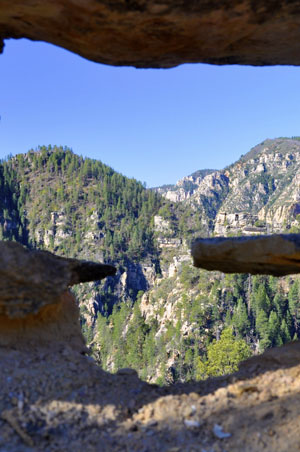
A short but steep climb with some difficult stretches to the east rim of Oak Creek Canyon. The signed trailhead is on the right (east) side of the road 100 yards north of the parking apron referred to under “Access” below. The trail begins as a level path heading north, then crosses a shallow drainage and begins a moderately steep, zig-zag ascent beneath a telephone line in partial shade. After climbing 550 feet in less than .5 miles, it bends to the east and levels out on the top of a finger ridge that runs from the east rim of the canyon. At .6 miles, the trail passes beside a picturesque reef of rock with several “windows”. Soon, the trail resumes its steep climb on a narrow ridge. 

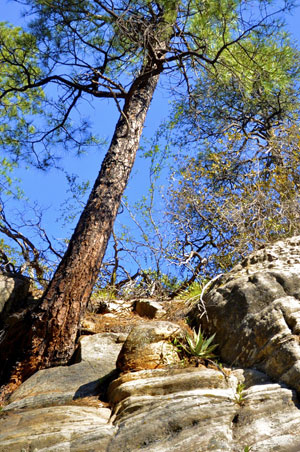
There are nice views over the West Fork area of the canyon to the west and of a deep chasm to the east. the trail levels off briefly at .8 miles, then begins a steep climb in the full shade of a mixed conifer and oak forest to the top of the east rim. This portion of the trail follows an old telephone line with only some post stubs remaining. The trail is difficult to follow in places but there are some cairns. The trail ends at a large rock cairn at 1.2 miles. Here, at the rim’s edge, there are views through the trees of the cliffs to the north. Return by the same route. This hike is suitable in summer, but do not attempt in winter if there is any snow on the slopes.

Trail Data

Distance: 1.25/2.5 miles (One way/Round Trip)
Time: 4 hours (Round Trip)
Elevation Change: 1000 ft.
Difficulty: Very Difficult
Map: Click here for a map of Telephone trail.

Trail Rating

VN:RO [1.9.8_1114]
Overall
Views
Difficulty
Rating: 4.2/5

View the Telephone Trail Slideshow and Commentary

Telephone Trail  Image 1
Telephone Trail  Image 2

Sedona Trail Rating System

The Hike House Sedona Trail Rating System provides actual hiker feedback and ratings of each of the Sedona hiking trails. The cumulative trail ratings for the Telephone Trail submitted by fellow hikers is located above with the Trail Data. Your trail feedback and ratings are an important resource for fellow hikers and provide a personal account of your trail experience from which others may learn. So please hike Sedona, help others, and rate a trail today!

Filed Under: Sedona Trail Rating System Tagged With: hiking sedona, Telephone Trail, The Hike House

Van Deren Cabin

Thursday, May 19, 2011 by The Hike House Leave a Comment

The Hike House Sedona Trail Rating System
Van Deren Cabin

The historic Van Deren Cabin is comprised of two hand-hewn log cabins joined together with a metal roof. Earl Van Deren, who homesteaded the acreage, built the two one-room cabins, including a red rock fireplace, in the 1890’s. Although the cabin site is surrounded by private ranchland, the cabin is owned by the Forest Service and is open to the public. Jeep tours regularly visit the cabin. This was the site for the Robert Mitchum film Blood on the Moon.

Trail Data

Distance: 0.5/1 mile (One way/Round Trip)
Time: 0.5 hours (Round Trip)
Elevation Change: 200 ft.
Difficulty: Easy

Trail Rating

VN:RO [1.9.8_1114]
Overall
Views
Difficulty
Rating: 3.3/5

Video Slideshow and Commentary Coming Soon

Sedona Trail Rating System

The Hike House Sedona Trail Rating System provides actual hiker feedback and ratings of each of the Sedona hiking trails. The cumulative trail ratings for the Van Deren Cabin submitted by fellow hikers is located above with the Trail Data. Your trail feedback and ratings are an important resource for fellow hikers and provide a personal account of your trail experience from which others may learn. So please hike Sedona, help others, and rate a trail today!

Filed Under: Sedona Trail Rating System Tagged With: hiking sedona, The Hike House, Van Deren Cabin

Turkey Creek Trail to House Mountain

Tuesday, May 17, 2011 by The Hike House 3 Comments

The Hike House Sedona Trail Rating System
Turkey Creek Trail
to House Mountain

This seldom used trail offers vistas and interesting geology. Follow the blocked road, taking the right fork at 0.3 miles. The unshaded road winds in a southwesterly direction with some gentle ups and downs for 1-1/2 miles to Turkey Creek Tank on the left. Here, the road bends to the left and dies out. The trail continues, crossing normally dry Turkey Creek and beginning a gradual climb in the sparse shade of pinyon pine and juniper. At 2-1/4 miles, it begins a moderately steep switchback ascent of the north face of House Mountain, a long extinct shield volcano. There are fine views of nearby red rock formations as well as more distant vistas north toward Wilson and Secret Mountains. The trail reaches the crest at nearly 3 miles and begins a gradual descent over basaltic lava. Soon the view over the ancient, heavily eroded caldera opens up and the opposite rim, dominated by the lava outcrop which gave the mountain its name, is visible. The trail continues, but this is a good stopping point. Return by the same route for a 6 mile roundtrip hike. This hike can be very hot in summer.

Trail Data

Distance: 3/6 miles (One way/Round Trip)
Time: 3 hours (Round Trip)
Elevation Change: 1000 ft.
Difficulty: Difficult

Trail Rating

VN:RO [1.9.8_1114]
Overall
Views
Difficulty
Rating: 3.7/5

Video Slideshow and Commentary Coming Soon

Sedona Trail Rating System

The Hike House Sedona Trail Rating System provides actual hiker feedback and ratings of each of the Sedona hiking trails. The cumulative trail ratings for the Turkey Creek Trail to House Mountain submitted by fellow hikers is located above with the Trail Data. Your trail feedback and ratings are an important resource for fellow hikers and provide a personal account of your trail experience from which others may learn. So please hike Sedona, help others, and rate a trail today!

Filed Under: Sedona Trail Rating System Tagged With: hiking sedona, The Hike House, Turkey Creek Trail to House Mountain

Thunder Mountain Trail

Tuesday, May 17, 2011 by The Hike House Leave a Comment

The Hike House Sedona Trail Rating System
Thunder Mountain Trail

An easy 1.4 mile loop can be made from the Thunder Mountain Trailhead using Lower Chimney Rock Trail and the southern portion of the Thunder Mountain Trail. From the loop, a short but steep route climbs up the Summit Trail to Chimney Rock Vista on top of a red rock hill with a great 360 degree view. A moderate 2.6 mile loop can be made using the Chimney Rock Pass Trail and more of the Thunder Mountain Trail. or, a moderate “figure 8” of 3 miles can be hiked using the same trails. The trailhead at the north end of Andante Drive can also be used as the starting point for these loops. These trails offer no shade. 

The Thunder Mountain Trail is the connector between these western trails and the eastern portion of the North Urban Trail System (described separately). The trail begins at the Thunder Mountain Trailhead and goes north, passing Chimney Rock. It then turns east and crosses the open area south of the sheer face of Capitol Butte, intersecting Teacup Trail at 1.7 miles. This is an easy, level trail, but there is no shade. The Teacup trail continues east. The Sugarloaf Trailhead is .3 miles to the south.

Trail Data

Distance: 2/4 miles (One way/Round Trip)
Time: 2 hours (Round Trip)
Elevation Change: 50 ft.
Difficulty: Easy

Trail Rating

VN:RO [1.9.8_1114]
Overall
Views
Difficulty
Rating: 3.3/5

Video Slideshow and Commentary Coming Soon

Sedona Trail Rating System

The Hike House Sedona Trail Rating System provides actual hiker feedback and ratings of each of the Sedona hiking trails. The cumulative trail ratings for the Thunder Mountain Trail submitted by fellow hikers is located above with the Trail Data. Your trail feedback and ratings are an important resource for fellow hikers and provide a personal account of your trail experience from which others may learn. So please hike Sedona, help others, and rate a trail today!

Filed Under: Sedona Trail Rating System Tagged With: hiking sedona, The Hike House, Thunder Mountain Trail

Thomas Point Trail

Tuesday, May 17, 2011 by The Hike House 1 Comment

The Hike House Sedona Trail Rating System
Thomas Point Trail

This is the southernmost of three trails that climb to the east rim of Oak Creek Canyon. Of the three, it offers the broadest and most varied views. However, it is also the hottest and longest. The Thomas Point Trail starts in a mixed conifer forest characteristic of Arizona canyons but quickly breaks out into more open chapparal. Above this point, vistas are broad and impressive with good views both down canyon, toward Sedona and the crimson bluffs near Slide Rock, and cross canyon to the steep cliffs of one of Oak Creek’s largest tributaries, West Fork Canyon. 

If you chose to continue all the way to the top, the trail winds through the manzanita and scrub oak to the canyon rim where you’ll be rewarded with a nice view of the San Francisco Peaks near Flagstaff, about thirty miles away.

Trail Data

Distance: 1.2/2.4 miles (One way/Round Trip)
Time: 1.5 hours (Round Trip)
Elevation Change: 900 ft.
Difficulty: Difficult

Trail Rating

VN:RO [1.9.8_1114]
Overall
Views
Difficulty
Rating: 4.5/5

Video Slideshow and Commentary Coming Soon

Sedona Trail Rating System

The Hike House Sedona Trail Rating System provides actual hiker feedback and ratings of each of the Sedona hiking trails. The cumulative trail ratings for the Thomas Point Trail submitted by fellow hikers is located above with the Trail Data. Your trail feedback and ratings are an important resource for fellow hikers and provide a personal account of your trail experience from which others may learn. So please hike Sedona, help others, and rate a trail today!

Filed Under: Sedona Trail Rating System Tagged With: hiking sedona, The Hike House, Thomas Point Trail

  • « Previous Page
  • 1
  • …
  • 3
  • 4
  • 5
  • 6
  • 7
  • …
  • 22
  • Next Page »

Sedona's #1 Hiking Guide Book
Discover the "Top 30 Trails"

Book a Guided Hike Adventure

Diabetic Boot Camp
Trail Experience of the Month
Sedona Hiking Clinic

Sedona Trail Rating System

  • Review Trail Ratings
  • Rate a Hiking Trail

Hike House Videos

  • The Hike House's 5 Elements
  • Sedona Trail Finder
  • The Hike House Channel on Youtube

Sign up for our Email Newsletter Email Newsletter icon, E-mail Newsletter icon, Email List icon, E-mail List icon

News

  • Hogs Trail
  • Hi Line Trail
  • Hangover Trail
  • Biological Soil Crust: Holding the Place in Place
  • Capturing Sedona’s Beauty

Like Us On Facebook

Latest Article

Hogs Trail

Wednesday, May 18, 2016 1 Comment

Hogs Trail One of the most underrated areas in Sedona is Munds Wilderness. Many people in the past would take on this area because the predominant trail for this area, Broken Arrow, is adjacent to a heavily traveled jeep road. A new day has arrived…while you still must hike a portion of Broken Arrow to get to Hogs, the trail departs from the … [Read More...]

Our Location


The Hike House
431 State Route 179
Sedona, AZ 86336
928-282-5820
Hours of Operation
Mon-Sat 9:00 am - 6:00 pm
Sunday   9:00 am - 5:00 pm
Click here for Map.

Return to top of page
© 2025 The Hike House
Log in