The Hike House

Tuesday, December 16th, 2025
Hiking Preparedness + Energy Supply + Apparel & Gear
  • Home
  • Sedona Trail Finder
    • About Sedona Trail Finder
    • List of 101 Sedona Hiking Trails
  • Hiking Preparedness
  • Energy Cafe
  • Trail Apparel
  • Grand Canyon Planning Station
  • Guided Hikes
  • Contact Us

Doe Mountain Trail

Tuesday, May 3, 2011 by The Hike House 22 Comments

The Hike House Sedona Trail Rating System
Doe Mountain Trail

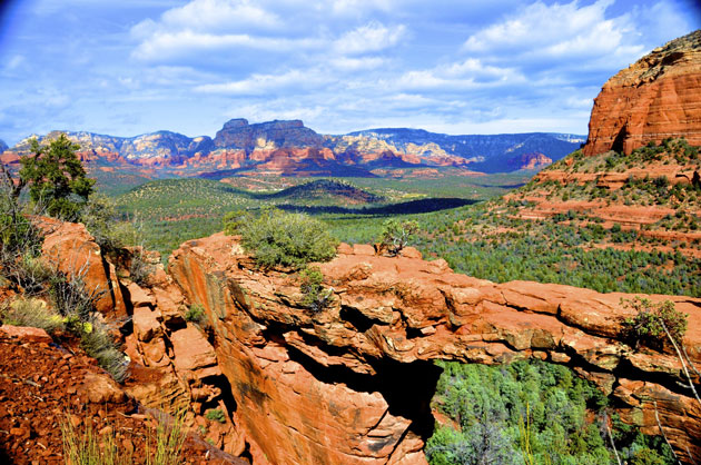
This trail not only provides a big dividend of scenery for a moderate outlay of exertion but it is easily accessible as well. From the ample parking lot at its trailhead, the Doe Mountain Trail switchbacks directly up the north side of this low, flat-topped Mesa. As you climb, you’ll want to take time out to enjoy the excellent views of the surrounding countryside. A layer of erosion resistant cap rock has given Doe Mountain its classic mesa shape and provides hikers with a great platform from which enjoy the panoramic view. From this 400 foot high perspective, you can see a number of the Sedona Red Rocks Country’s more prominent landmarks . You’ll see Bear, Maroon and Wilson mountains, Loy, Boynton and Secret canyons, Chimney Rock, and the Cockscomb to name a few. Sedona is visible to the east and off to the south, Munds Mountain and Sycamore Pass mark the location of Sycamore Canyon and the Verde Valley.

Trail Data

Distance: 0.75/1.5 miles (One way/Round Trip)
Time: 2 hours (Round Trip)
Elevation Change: 400 ft.
Difficulty: Moderate

Trail Rating

VN:RO [1.9.8_1114]
Overall
Views
Difficulty
Rating: 4.1/5

Video Slideshow and Commentary Coming Soon

Sedona Trail Rating System

The Hike House Sedona Trail Rating System provides actual hiker feedback and ratings of each of the Sedona hiking trails. The cumulative trail ratings for the Doe Mountain Trail submitted by fellow hikers is located above with the Trail Data. Your trail feedback and ratings are an important resource for fellow hikers and provide a personal account of your trail experience from which others may learn. So please hike Sedona, help others, and rate a trail today!

Filed Under: Sedona Trail Rating System Tagged With: Doe Mountain Trail, hiking sedona, The Hike House

Devil’s Bridge Trail

Tuesday, May 3, 2011 by The Hike House 22 Comments

The Hike House Sedona Trail Rating System
Devil’s Bridge Trail

This popular hike has attractions for both casual hikers who lack the desire or the stamina to stray too far from civilization, and the more adventurous outdoors enthusiasts. Starting at the parking area, follow the trailmarker that points the way to Devil’s Bridge Trail. You’ll find the early going effortless; the trail, originally built for jeep travel, is smooth and clear and leads you through washes filled with juniper and prickly pear cactus. 

The path slowly inclines uphill, gently growing more steep as you progress. There’s some beautiful scenery to absorb as you proceed upward, but you’ve still got a ways to go before you get to see Devil’s Bridge itself.

After you’ve walked about three-quarters of a mile from the parking area, the trail will divide. Head down the path to the left and you’ll end up at the base of the bridge. For a cool view, stand directly under the 50 foot high arch and look toward the heavens — and take care not to strain your neck.
But it’s the topside trail that provides the biggest treat. Follow it up a steep, natural rock staircase to a wide open area that offers some fantastic views. Keep going, and you’ll reach yet another level that leads directly to Devil’s Bridge.

If you have the nerve, you can walk across the top; once you’re on it you’ll find it’s not such a tough walk. But use caution and exercise some common sense; it’s a long way down.

Trail Data

Distance: 1/2 miles (One way/Round Trip)
Time: 1 hour (Round Trip)
Elevation Change: 320 ft.
Difficulty: Moderate

Trail Rating

VN:RO [1.9.8_1114]
Overall
Views
Difficulty
Rating: 4.1/5

View the Devil’s Bridge Trail Slideshow and Commentary

Devil's Bridge Trail Image

Sedona Trail Rating System

The Hike House Sedona Trail Rating System provides actual hiker feedback and ratings of each of the Sedona hiking trails. The cumulative trail ratings for the Devil’s Bridge Trail submitted by fellow hikers is located above with the Trail Data. Your trail feedback and ratings are an important resource for fellow hikers and provide a personal account of your trail experience from which others may learn. So please hike Sedona, help others, and rate a trail today!

Filed Under: Sedona Trail Rating System Tagged With: Devil's Bridge Trail, hiking sedona, The Hike House

Deadman’s Pass Trail

Tuesday, May 3, 2011 by The Hike House 3 Comments

The Hike House Sedona Trail Rating System
Deadman’s Pass Trail

This trail features easy riding on fast open trails next to wilderness canyons and is a “connector trail” between the Long Canyon Trail and the Boynton Canyon Trail. This trail has a little bit of everything in the way of riding terrain – dirt road at the start, wide dirt trail along Long Canyon Trail and finally single track riding (some over rocks) on the Deadmans Pass trail.

Trail Data

Distance: 1.4/2.8 miles (One way/Round Trip)
Time: 1.5 hours (Round Trip)
Elevation Change: 175 ft.
Difficulty: Easy
Map: Click here for a map of Deadman’s Pass Trail.

Trail Rating

VN:RO [1.9.8_1114]
Overall
Views
Difficulty
Rating: 2.7/5

View the Deadman’s Pass Trail Slideshow and Commentary

Sedona Trail Rating System

The Hike House Sedona Trail Rating System provides actual hiker feedback and ratings of each of the Sedona hiking trails. The cumulative trail ratings for the Deadman’s Pass Trail submitted by fellow hikers is located above with the Trail Data. Your trail feedback and ratings are an important resource for fellow hikers and provide a personal account of your trail experience from which others may learn. So please hike Sedona, help others, and rate a trail today!

Filed Under: Sedona Trail Rating System Tagged With: Deadman's Pass Trail, hiking sedona, The Hike House

Dawa Trail

Tuesday, May 3, 2011 by The Hike House 2 Comments

The Hike House Sedona Trail Rating System
Dawa Trail

From its trailhead, the Dawa Trail goes south a short way before bending to the west along a closed jeep road with some good views. It meets the Cockscomb Trail at .9 miles and turns sharply southeast to follow it for 100 feet. The Cockscomb Trail then splits off to the southwest and the Dawa Trail continues southeast for .8 miles before ending at the Arizona Cypress Trail beside Dry Creek.

Trail Data

Distance: 1.25/2.5 miles (One way/Round Trip)
Time: 1.5 hours (Round Trip)
Elevation Change: 80 ft.
Difficulty: Moderate

Trail Rating

VN:RO [1.9.8_1114]
Overall
Views
Difficulty
Rating: 2.3/5

Video Slideshow and Commentary Coming Soon

Sedona Trail Rating System

The Hike House Sedona Trail Rating System provides actual hiker feedback and ratings of each of the Sedona hiking trails. The cumulative trail ratings for the Dawa Trail submitted by fellow hikers is located above with the Trail Data. Your trail feedback and ratings are an important resource for fellow hikers and provide a personal account of your trail experience from which others may learn. So please hike Sedona, help others, and rate a trail today!

Filed Under: Sedona Trail Rating System Tagged With: Dawa Trail, hiking sedona, The Hike House

Crescent Moon Ranch

Tuesday, May 3, 2011 by The Hike House 3 Comments

The Hike House Sedona Trail Rating System
Crescent Moon Ranch

Crescent Moon Ranch lies along Oak Creek directly across from Cathedral Rock. The ranch is a beautiful and popular day-use area for picnicking, photography, wading, sunbathing and walking. The Cathedral Rock vistas seen in so many photographs of the area were taken from this location. This hike is a scenic creekside stroll through riparian vegatation beneath the shadow of the eroding red buttes, framed by cottonwood and sycamore trees. The trail begins in the meadow and passes the old John Lee homestead, built in the late 1800’s. The path follow the creek upstream along the base of Cathedral Rock to a vortex site known as Buddah Beach. The area is studded with hundreds of hand-stacked prayer rocks.

Trail Data

Distance: 0.75/1.5 miles (One way/Round Trip)
Time: 1 hour (Round Trip)
Elevation Change: 0 ft.
Difficulty: Not Difficult

Trail Rating

VN:RO [1.9.8_1114]
Overall
Views
Difficulty
Rating: 3.1/5

Video Slideshow and Commentary Coming Soon

Sedona Trail Rating System

The Hike House Sedona Trail Rating System provides actual hiker feedback and ratings of each of the Sedona hiking trails. The cumulative trail ratings for the Crescent Moon Ranch submitted by fellow hikers is located above with the Trail Data. Your trail feedback and ratings are an important resource for fellow hikers and provide a personal account of your trail experience from which others may learn. So please hike Sedona, help others, and rate a trail today!

Filed Under: Sedona Trail Rating System Tagged With: Crescent Moon Ranch, hiking sedona, The Hike House

  • « Previous Page
  • 1
  • …
  • 12
  • 13
  • 14
  • 15
  • 16
  • …
  • 21
  • Next Page »

Sedona's #1 Hiking Guide Book
Discover the "Top 30 Trails"

Book a Guided Hike Adventure

Diabetic Boot Camp
Trail Experience of the Month
Sedona Hiking Clinic

Sedona Trail Rating System

  • Review Trail Ratings
  • Rate a Hiking Trail

Hike House Videos

  • The Hike House's 5 Elements
  • Sedona Trail Finder
  • The Hike House Channel on Youtube

Sign up for our Email Newsletter Email Newsletter icon, E-mail Newsletter icon, Email List icon, E-mail List icon

News

  • Hogs Trail
  • Hi Line Trail
  • Hangover Trail
  • Biological Soil Crust: Holding the Place in Place
  • Capturing Sedona’s Beauty

Like Us On Facebook

Latest Article

Hogs Trail

Wednesday, May 18, 2016 1 Comment

Hogs Trail One of the most underrated areas in Sedona is Munds Wilderness. Many people in the past would take on this area because the predominant trail for this area, Broken Arrow, is adjacent to a heavily traveled jeep road. A new day has arrived…while you still must hike a portion of Broken Arrow to get to Hogs, the trail departs from the … [Read More...]

Our Location


The Hike House
431 State Route 179
Sedona, AZ 86336
928-282-5820
Hours of Operation
Mon-Sat 9:00 am - 6:00 pm
Sunday   9:00 am - 5:00 pm
Click here for Map.

Return to top of page
© 2025 The Hike House
Log in