The Hike House

Monday, December 15th, 2025
Hiking Preparedness + Energy Supply + Apparel & Gear
  • Home
  • Sedona Trail Finder
    • About Sedona Trail Finder
    • List of 101 Sedona Hiking Trails
  • Hiking Preparedness
  • Energy Cafe
  • Trail Apparel
  • Grand Canyon Planning Station
  • Guided Hikes
  • Contact Us

Cow Pies

Tuesday, May 3, 2011 by The Hike House 1 Comment

The Hike House Sedona Trail Rating System
Cow Pies

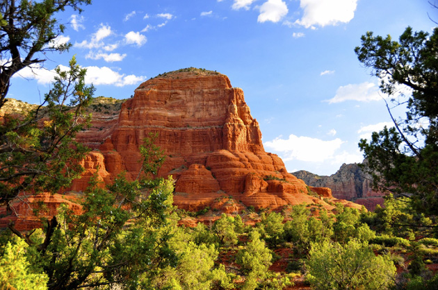
The Cow Pies are multlevel, flat red rock mounds located in the middle of Bear Wallow Canyon. From the edge of the enormous slick rock mounds are world-class views into the canyon below. The circular sandstone formations are one of Sedona’s foremost vortex sites. Stones carefully placed in a circle, known as medicine wheels, are used as an antenna to attract positive energies. Medicine wheels are usually seen on formation to the next. John Wayne was filmed at this site while acting in the 1940’s film Angel and the Batman. If you love Red Rocks then you will love Cow Pies.

Trail Data

Distance: 1.5/3 miles (One way/Round Trip)
Time: 1.5 hours (Round Trip)
Elevation Change: 100 ft.
Difficulty: Easy

Trail Rating

VN:RO [1.9.8_1114]
Overall
Views
Difficulty
Rating: 3.3/5

View the Wilson Mountain Trail Slideshow and Commentary

Sedona Trail Rating System

The Hike House Sedona Trail Rating System provides actual hiker feedback and ratings of each of the Sedona hiking trails. The cumulative trail ratings for the Cow Pies submitted by fellow hikers is located above with the Trail Data. Your trail feedback and ratings are an important resource for fellow hikers and provide a personal account of your trail experience from which others may learn. So please hike Sedona, help others, and rate a trail today!

Filed Under: Sedona Trail Rating System Tagged With: Cow Pies, hiking sedona, The Hike House

Courthouse Butte Loop

Tuesday, May 3, 2011 by The Hike House 5 Comments

The Hike House Sedona Trail Rating System
Courthouse Butte Loop

Courthouse Butte Loop: To get to this wonderful trail, take the wide Bell Rock Pathway from the kiosk toward Bell Rock. It climbs gently and at ½ mile there is a signed intersection with the Courthouse Butte Loop Trail. Continue ahead on the wide trail (this description is for taking the loop clockwise). The trail continues a gentle climb circling to the left of Bell Rock. It levels out at 1 mile and curves to the right below the slopes of Bell Rock. Follow the large cairns to the 1½ mile point where the wide Pathway turns north (left) and a sign shows the Courthouse Butte Loop Trail branching to the right. Go right. This narrower trail passes to the left of Courthouse Butte heading toward Lee Mountain. At 2¼ miles, the trail passes to the right of a prominent dome-shaped outcrop, and then gradually descends, entering Wilderness. It enters a dry wash at 3 miles, circles to the right over bare rock and climbs out onto level ground as it leaves the Wilderness area and continues to circle Courthouse Butte. Approaching Bell Rock, the trail meets the pathway once again at 3¾ miles. Go left, retracing the entry route for ½ mile to return to the kiosk. The loop is mostly unshaded and can be hot in summer.

Trail Data

Distance: 2.125/4.25 miles (One way/Round Trip)
Time: 2 hours (Round Trip)
Elevation Change: 250 ft.
Difficulty: Moderate
Map: Click here for a map of Courthouse Butte Loop trail.

Trail Rating

VN:RO [1.9.8_1114]
Overall
Views
Difficulty
Rating: 3.6/5

View the Courthouse ButteTrail Slideshow and Commentary

Courthouse Butte Loop Trail Image

Sedona Trail Rating System

The Hike House Sedona Trail Rating System provides actual hiker feedback and ratings of each of the Sedona hiking trails. The cumulative trail ratings for the Courthouse Butte Loop submitted by fellow hikers is located above with the Trail Data. Your trail feedback and ratings are an important resource for fellow hikers and provide a personal account of your trail experience from which others may learn. So please hike Sedona, help others, and rate a trail today!

Filed Under: Sedona Trail Rating System Tagged With: Courthouse Butte Loop, hiking sedona, The Hike House

Cookstove Trail

Tuesday, May 3, 2011 by The Hike House 4 Comments

The Hike House Sedona Trail Rating System
Cookstove Trail

Originally built to provide access for forest firefighters to Oak Creek Canyon’s wooded slopes, Cookstove Trail now offers nature lovers a scenic route to the canyon rim. The trail starts from the north end of Pine Flat Campground and immediately begins switchbacking up the steep slope of the canyon’s east wall. It climbs through an area forested with stands of mixed conifers, Gambel Oaks and both Utah and alligator junipers. The trees part at a number of points along the trail offering good views of the buff- colored cliffs of Coconino Sandstone and the remnants of an old volcano across Oak Creek. There are also some good views of the Route 89A switchbacks that lead into the canyon. 

At the top of the climb, an outcrop of volcanic basalt provides a lunch stop where you can enjoy the view before heading back down the trail or continuing south along the canyon rim to the Harding Springs Trail for an alternate descent back to the highway.

Trail Data

Distance: 0.8/1.6 miles (One way/Round Trip)
Time: 1.5 hours (Round Trip)
Elevation Change: 800 ft.
Difficulty: Very Difficult

Trail Rating

VN:RO [1.9.8_1114]
Overall
Views
Difficulty
Rating: 4.3/5

Video Slideshow and Commentary Coming Soon

Sedona Trail Rating System

The Hike House Sedona Trail Rating System provides actual hiker feedback and ratings of each of the Sedona hiking trails. The cumulative trail ratings for the Cookstove Trail submitted by fellow hikers is located above with the Trail Data. Your trail feedback and ratings are an important resource for fellow hikers and provide a personal account of your trail experience from which others may learn. So please hike Sedona, help others, and rate a trail today!

Filed Under: Sedona Trail Rating System Tagged With: Cookstove Trail, hiking sedona, The Hike House

Coffeepot Rock

Tuesday, May 3, 2011 by The Hike House 1 Comment

The Hike House Sedona Trail Rating System
Coffeepot Rock

The prominent Coffeepot Rock is shaped like a percolator style coffee pot with a spout. The richly colored formation is visible from the entire Sedona area, lying amongst the massive cliffs fronting the town’s north edge. It forms the west wall of the entrance to Soldier Wash. This hike begins on the Teacup Trail and leads up to a rock ledge under the spout of Coffeepot Rock.

Trail Data

Distance: 0.5/1 mile (One way/Round Trip)
Time: .75 hours (Round Trip)
Elevation Change: 400 ft.
Difficulty: Not Difficult

Trail Rating

VN:RO [1.9.8_1114]
Overall
Views
Difficulty
Rating: 2.5/5

Video Slideshow and Commentary Coming Soon

Sedona Trail Rating System

The Hike House Sedona Trail Rating System provides actual hiker feedback and ratings of each of the Sedona hiking trails. The cumulative trail ratings for the Coffeepot Rock submitted by fellow hikers is located above with the Trail Data. Your trail feedback and ratings are an important resource for fellow hikers and provide a personal account of your trail experience from which others may learn. So please hike Sedona, help others, and rate a trail today!

Filed Under: Sedona Trail Rating System Tagged With: Coffeepot Rock, hiking sedona, The Hike House

Cockscomb Trail

Tuesday, May 3, 2011 by The Hike House 2 Comments

The Hike House Sedona Trail Rating System
Cockscomb Trail

This interconnected series of trails lies at the northern edge of Sedona near Dry Creek. included are the Girdner, Arizona Cypress, Dawa, Cockscomb, Rupp, OK Trails. These trails may be reached using the three trailheads shown below or by using either of the two Girdner trailheads. The Girdner Trail and its access are fully described in a separate trail sheet. Various loop hikes can be made by combining all or parts of several trails and a number of one-way hikes can be made using arranged transportation at a second trailhead. In general, these trails are well suited to biking, have easy to moderate grades with little overall elevation change, are well signed, but have sparse shade. 

The Cockscomb Trail goes south from its trailhead along a jeep road for .3 miles, bends west for .2 miles, then goes southeast along a closed jeep road skirting the face of Doe Mountain. It intersects the Dawa Trail at 1 mile, turns to the southwest, and ends at 1.8 miles near the Cockscomb. From here, the Cockscomb Trail continues along the old road as the Rupp Trail. It bends to the east and there are nice views all around as it crosses a broad, open expanse before ending at 1.2 miles as it drops down into the Dry Creek drainage and meets the Girdner Trail.

Trail Data

Distance: 2/4 miles (One way/Round Trip)
Time: 3 hours (Round Trip)
Elevation Change: 80 ft.
Difficulty: Moderate

Trail Rating

VN:RO [1.9.8_1114]
Overall
Views
Difficulty
Rating: 3.2/5

Video Slideshow and Commentary Coming Soon

Sedona Trail Rating System

The Hike House Sedona Trail Rating System provides actual hiker feedback and ratings of each of the Sedona hiking trails. The cumulative trail ratings for the Cockscomb Trail submitted by fellow hikers is located above with the Trail Data. Your trail feedback and ratings are an important resource for fellow hikers and provide a personal account of your trail experience from which others may learn. So please hike Sedona, help others, and rate a trail today!

Filed Under: Sedona Trail Rating System Tagged With: Cockscomb Trail, hiking sedona, The Hike House

  • « Previous Page
  • 1
  • …
  • 14
  • 15
  • 16
  • 17
  • 18
  • …
  • 22
  • Next Page »

Sedona's #1 Hiking Guide Book
Discover the "Top 30 Trails"

Book a Guided Hike Adventure

Diabetic Boot Camp
Trail Experience of the Month
Sedona Hiking Clinic

Sedona Trail Rating System

  • Review Trail Ratings
  • Rate a Hiking Trail

Hike House Videos

  • The Hike House's 5 Elements
  • Sedona Trail Finder
  • The Hike House Channel on Youtube

Sign up for our Email Newsletter Email Newsletter icon, E-mail Newsletter icon, Email List icon, E-mail List icon

News

  • Hogs Trail
  • Hi Line Trail
  • Hangover Trail
  • Biological Soil Crust: Holding the Place in Place
  • Capturing Sedona’s Beauty

Like Us On Facebook

Latest Article

Hogs Trail

Wednesday, May 18, 2016 1 Comment

Hogs Trail One of the most underrated areas in Sedona is Munds Wilderness. Many people in the past would take on this area because the predominant trail for this area, Broken Arrow, is adjacent to a heavily traveled jeep road. A new day has arrived…while you still must hike a portion of Broken Arrow to get to Hogs, the trail departs from the … [Read More...]

Our Location


The Hike House
431 State Route 179
Sedona, AZ 86336
928-282-5820
Hours of Operation
Mon-Sat 9:00 am - 6:00 pm
Sunday   9:00 am - 5:00 pm
Click here for Map.

Return to top of page
© 2025 The Hike House
Log in